Data Source#
BigEarthNet contains 590,326 pairs of Sentinel-1 and Sentinel-2 image patches. Two datasets belong to the BigEarthNet collection:
BigEarthNet-S2 (BigEarthNet with Sentinel-2 image patches)
BigEarthNet-S1 (BigEarthNet wiht Sentinel-1 image patches)
BigEarthNet-S2, initially named BigEarthNet, was released first. After adding the BigEarthNet-S1 archive, the term BigEarthNet has become an umbrella term for both datasets.
Note
If both are used in a multi-modal fashion, the combined dataset is called BigEarthNet-MM. So when referring to BigEarthNet-MM it technically refers to separate dataset files.
Important
Due to historical reasons, BigEarthNet and BigEarthNet-S2 are often used interchangeably.
The images cover ten different European countries that were acquired from June 2017 to May 2018, with the goal to acquire all the chosen locations in different seasons[1].
Sensed Countries
Austria
Belgium
Finland
Ireland
Kosovo
Lithuania
Luxembourg
Portugal
Serbia
Switzerland
Sentinel-2#
Sentinel-2 is a high-resolution, multispectral imaging mission from the European Union’s Copernicus Program for Earth observation. The Sentinel-2 mission is based on a constellation of two identical satellites (Sentinel-2A and Sentinel-2B) in the same orbit. Each satellite has a Multi-Spectral Instrument (MSI) that samples 13 spectral bands (four bands at 10m, six bands at 20m and three bands at 60m spatial resolution) with a high revisit time (10 days at the equator with one satellite, and 5 days with 2 satellites under cloud-free conditions which results in 2–3 days at mid-latitues). The following figure visualizes the spectrum of each band grouped by their spatial resolution.
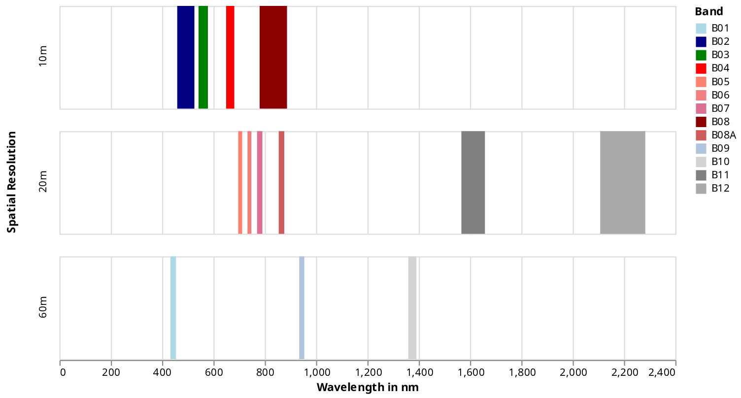
Sentinel-2 bands grouped by spatial resolution#
The spectrums range from visible (380nm–700nm), near-infrared (700nm–1100nm) to short-wave infrared (1100nm–3000nm) light. The low-spatial resolution 60m bands are designed for aerosol (B01), water-vapor (B09), and cirrus cloud (B10) detection.
BigEarthNet does not include band B10 as B10 provides no surface-level information [5]. Band B10 is dropped after converting a Sentinel-2 L1C data product, which encodes the TOA, to a Sentinel-2 L2A product containing the BOA data. See the official Sentinel-2 data products page for more information.
The 20m bands in the near-infrared range (B05, B06, B07, B8A) are vital for differentiating vegetation from other objects. The remaining 20m bands in the short-wave infrared spectrum (B11, B12) are helpful for snow, ice, and cloud discrimination [1].
The 10m spatial resolution bands B04, B03, and B02 are the red, green, and blue (RGB) channels. The last 10m resolution band, B08, covers a broader spectrum than B08A but is less resistant against water vapor contaminating the spectral reflectance. As some applications suffer from possible contamination, the narrower, lower spatial resolution band B08A was added. To cover all use-cases, both bands were included, even if they overlap in the sensed spectrums [4]. Concatenating these spectrums results in images with twelve channels.
Important
BigEarthNet-S2 dropped channel B10 from the original Sentinel-2 data, as the band does not contain surface-level information. (Or more specifically, B10 is dropped during the BOA calculation with the
sen2cortool.)The bands B08 and B8A are included, even if they overlap in the sensed spectral reflectivity.
Allows the user to decide how to handle the overlap. Refer to Sentinel-2 Heritage document [4] for more details.
For a more detailed overview of the Sentinel-2 mission, please take a look:
Sentinel-1#
ToDo
Add some information about Sentinel-1